Register with Plumtri!
Register on plumtri as an Individual or as an Organisation to gain access to all of its useful features and remain updated on the latest R&I news, events and funding opportunities.
-
 Welcome to plumtriA platform for Research & Innovation
 -
 Looking for Funding?Check out the current open calls
 -
 Register today to start receiving our monthly newsletter
 -
 Looking to partner up?Search our list of registered profiles
 -
 You have questions on a particular funding programme?
Surveilling Marine Litter from Space

By using satellites currently in orbit, researchers managed to acquire an unprecedented view of the emissions and accumulation areas of marine litter. This opens up multiple possibilities to improve the fight against plastic pollution.
Marine littering has grown into a global environmental problem, and is recognised as an urgent priority on international sustainability agendas. A full 80% of this litter is plastic. Continued efforts in mapping its presence in water surfaces have produced important results, such as the discovery of the so-called plastic island in the middle of the Pacific and Atlantic Oceans. Due to the vastness of the ocean, however, field measurements remain limited. This makes satellite-based observations one of the best hopes for large-scale monitoring of marine pollution.
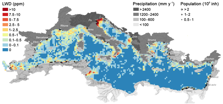
In a work published today in Nature Communication, a group of international researchers, including JRC, established that accumulation patches of floating litter (also called windrows) can be identified in images taken by Copernicus satellites. By automatically analysing more than 300 000 remote sensing images of the Mediterranean Sea, researchers identified thousands of litter windrows. This new analysis made it possible to detect the most polluted areas, determine seasonal variability patterns and the extent of land-based emissions.
Continue reading this article on the below link.
